Wednesday, July 29, 2015

Volunteering at the Kashevaroff Site


While I was in Kodiak I was able to participate in the Alutiiq Museum's Community Archaeology excavation as a volunteer. It was very exciting to show up and not be in charge. I got to dig, dig, dig, all day long, which is not something I often got to do when I was helping Patrick direct the excavations a few years ago. And guess what - when you move a lot of dirt you find a lot of stuff!

Quite literally, I found a very nice artifact on only my second trowel scrape of my first morning. At first glance it looked like a ground slate point, but upon further inspection I could see that it was not sharp, nor was it ever meant to be sharp - it was made to be blunt. Patrick suggested a "boot creaser" or something of the sort. I think that's a good explanation; the Alutiiq were certainly making a lot of clothing and other things from animal skins.

Blunt ground slate artifact - boot creaser?? (photo courtesy of Patrick)
Huge and fancy ground slate point (not found by me!)
Ground slate point with a groove down the middle (photo courtesy of Patrick)
This years' excavation is at the Kashevaroff Site where Ryan conducted a ground penetrating radar (GPR) survey in 2013. He noticed a slight depression in this area, surveyed it with the GPR, and came to the conclusion that there was some sort of archaeological pit below the surface - maybe a house pit? Catherine is supervising the excavation in this part of the site this year and while they still have a lot of dirt to move, it does look like there is a large pit, but it is not a house pit. It is full of charcoal and fire cracked rock and is something we've been calling "smoke processing pits." It appears to have been filled in by a volcanic ash deposited around 3800 years ago.


One of the more familiar aspects of digging at Community Archaeology was that it was HOT. We were all sweltering in our units, even though I was in thin pants and a t-shirt. It is always amazing that it can feel so unbearably warm when the official temperature is 62 degrees Farenheit, but I swear to you, the hottest I have ever been is while digging in Women's Bay. It's not like I've never been or worked in actual hot weather (I spent an entire summer working in CA where the temperature never dropped below 96 degrees during the day). I have no explanation except that the airport's weather station thermometer must be perpetually broken.

Monday, July 27, 2015

Berries in Kodiak


Berry season is upon us in Kodiak! When my friend Sam and I arrived on Friday we spent our first hour picking blueberries with my mom and raked in four quarts in only an hour. Slamonberries are also at their peak. This weekend, with the company of five archaeology friends, my parents and I picked four gallons in an hour. The berries are so thick it was overwhelming. As if that wasn't enough, we got a couple of gallons just in my parents' yard over the weekend. Time to make some jelly!


Oh, and we celebrated someone's 65th birthday!


- Posted using BlogPress from my iPhone

Monday, July 20, 2015

Denali Highway

This weekend my cousin and I took off Thursday night for a 3+ day road trip to see the Denali Highway. Despite having collectively lived over 30 years in Alaska, neither of us had ever been on this highway before. We went counter clockwise, camping one night on the Glenn Highway and two nights on the Denali Highway. We had cloudy weather, sporadic rain, and a few bugs, but nothing a true Alaskan could complain about. We also saw copious amounts of fireweed in bloom, our first ripe blueberries of the season, a fox, a caribou, and fleeting views of the foothills of the Alaska Range.

I'm some ways it's good that we didn't get to see the Alaska Range on a clear day; it gives us a reason to go back soon.


Overlooking Tangle Lakes Campground


Tangle Lakes


Light-colored fireweed


Brushkana campground

- Posted using BlogPress from my iPhone

Wednesday, July 15, 2015

Katmai Bay


Looking for a place to cross Mageik Creek
On Thursday morning we packed up our tents and moved out of Mageik Creek canyon in a hurry since sitting around in the wind wasn't all that fun. Once we were out in Katmai River valley heading toward the coast, our first move was to cross Mageik Creek - a narrow but swift-moving creek. The water was well up to our thighs, but with care and some group-river crossing techniques, it was safely crossable. When we continued across the valley and arrived at the Katmai River, we wanted to laugh. It's so braided and shallow it was never even above our ankles. We continued to cross the river valley, heading to the southeast, and crossed a series of other swift thigh-deep channels (not sure if they have a name). Eventually we came to the area where the Soluka and Katmai River Valleys meet, and we continued to head southeast across the Soluka River. The last several hours of this crossing were...interesting.
Ryan crossing the Katmai River
The topo maps show the Soluka River as MANY braided channels. As it turns out, it's more like one giant, shallow river plane. There was basically water as far as we could see, and we had to cross it. Lucky for us, the water was pleasantly warm. For the most part it was ankle to knee deep, however, we also sank into the mud anywhere from a couple of inches up to our thighs on occasion. Most of us found it was best just to walk in socks. The shoes we had used for other river crossings just filled up with sand/mud and became heavy. We walked through this type of water and mud for a solid three hours, into a pretty decent head-wind. There were few places to rest, since we were surrounded by water. It is not lost on us that we were very fortunate to have nice weather on this day.
Crossing the Soluka River...for three hours

Still crossing the Soluka

When we finally reached the coast that evening, we were elated to see the beautiful white sand beach that would be our landing strip. Despite being incredibly fortunate with the weather and being in such an awe-inspiring landscape, we pretty much plopped down our packs, set up our camp, and got out the sat phone to arrange our pickup a day earlier than scheduled. We didn't move until our plane came the next day a little after noon. We were completely beat. But sometimes, laying on a beach with your feet up on a log listening to the waves lap on the sandy beach at low tide is just what you need to recover and reflect.

Arriving at Katmai Bay after a long day
Katmai Bay
Taking down our tents at our last camp
Ryan walking out to meet Keller

Tuesday, July 14, 2015

Mageik Creek Canyon


View out the Katmai River Valley toward the Pacific and Kodiak Island
View back toward the pass and Mageik Mountain from the shoulder of Observation Mountain
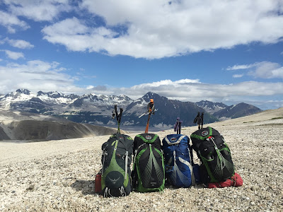
Our collection of Osprey Exos packs on Observation Mountain

Mageik Creek Canyon
After we hiked through Katmai Pass we climbed over the eastern shoulder of Observation Mountain and got our first view of the Pacific Coast, and even Kodiak Island. It was windy, so we dropped over Observation and tucked into Mageik Creek Canyon for some shelter. However, the wind changed direction and picked up in the middle of the night and we found ourselves scrambling to put rocks on our tent lines. We also had our fair share of the famous Katmai pumice-sand blowing into our tent and coating all our gear (and our faces). But I suppose it would have been a shame to spend almost a week in the park and not experience this lovely phenomenon.

The canyon also had a well-worn bear trail and tracks everywhere. Luckily we had a borrowed electric bear fence (thanks, Patrick!) that gave us some peace of mind. There really is no getting away from bear tracks in this part of Katmai.

Mageik Creek Canyon, carved into sedimentary rock, is a deep canyon. I honestly didn't expect this see this type of canyon out here. Despite the wind and blowing pumice, I was glad we had the chance to hang out in it.

Mageik Creek Canyon
Windy morning in Mageik Creek Canyon


Thursday, July 9, 2015

Katmai Pass

Leaving the Valley of Ten Thousand Smokes

Despite the awesomeness of Katmai's caldera and Novarupta, if I had to pick a favorite place along our route, it would be the section from Katmai Pass to Observation Mountain. I had never seen any photos of this area, so it's odd combination of pumice, lava, and lush but spotty vegetation was constantly surprising.

Mageik Creek and Trident Lava Flows
Moose tracks right through Katmai Pass

Big bear prints
Mageik Creek looking back toward the pass
There were TONS of Monkeyflowers in this area
Once you pass through Katmai Pass, there are old lava flows to the west from Mageik volcano and new lava flows from the 1950s to the east from Trident volcano that funnel you into a small river valley. That valley is the only easy travel corridor around, so all sorts of animals use it. As always, following game trails has its pluses and minuses - animals usually know the best route to travel, but you're also bound to run into some of them eventually. We ran into a bear just on the other side of the tight river valley, so we had space to swing wide and avoid the bear (who seemed none too scared of us).

Well-worn bear trail where they step in the same prints every time
A bear (very small in the picture) just chillin' in our path, so we went around

Novarupta

The Novarupta plug and Falling Mountain
After we climbed to the caldera, hiking to Novarupta was our "rest" day. I don't think I can accurately describe in words how freaking cool it was to stand in the site of the largest eruption of the 20th century. All of that pumice in the Valley of Ten Thousand Smokes and all of the ash that fell on Kodiak came from this volcano (Novarupta siphoned material from below Mount Katmai, and as a result Katmai collapsed creating a crater/caldera, but Katmai itself did not erupt). Ryan read that the Novarupta volcano is actually quite a bit wider than the plug that you see today - that plug is just the evidence of the last little event of the eruption.

We were able to climb up onto and around the plug. This is the only area in the valley that is still steaming (at least that we saw). Even around the base of the plug there were tons of steam vents. We saw some really nice flat spots at the base of the Novarupta plug on the north side that would be great for camping if anyone is looking for a good spot. There were still water sources from snow melt in this area when we were there, but with a low snow year like this, they won't last all summer.

pumice
This crack in the rock is a steam vent


On top of the Novarupta plug

Wednesday, July 8, 2015

Katmai Caldera

Katmai Caldera
When I was 12 or 13 I got a good look at the Katmai Caldera on a crystal clear day from a small plane on a flight from Kodiak to King Salmon. I've always been fascinated by volcanic eruptions, but that dark turquoise lake made an impression on me and I haven't been able to get it out of my head since then. From what I had read and heard from others, hiking to the caldera from The Valley of Ten Thousand smokes is challenging, although not technical. From the huts it's between 16 and 18 miles round trip and about 3500 feet of elevation gain. I most definitely wanted to get up there, but I tried not to set my heart on it because I knew we could easily be thwarted by bad weather or simply fatigue.

I was not disappointed, however. The first morning we were at the huts the weather seemed decent so we went for it. From the base of the mountain, just getting onto it seemed daunting. We had advice on the route from a ranger though, so we went for it up a steep snow patch. That was probably the hardest physical part of the climb. We then traversed along some squishy pumicey rocky terrain, and then up another rise (though not quite as steep) on a glacier. At that point it started to rain fairly hard, it looked pretty socked in above us, and we seriously wondered whether it was worth it to continue. But at that point we were far enough into the climb that if we turned around, there was no way we were ever coming back. We keep trudging uphill as the rain turned to wet snow. Even when we could see the rim of the caldera, I tried not to let myself believe it was actually THE rim until we were there and I could see the lake myself.

Baked Mountain in the morning sun - all of the light colored stuff is pumice, the entire mountain is covered in pumice!
John and Ryan looking toward Katmai from the pass between Baked and Broken Mountains
Arriving at the daunting base of Katmai
Climbing up toward the caldera rim
So excited to have made it!


It was just as impressive as I had gathered from the airplane, perhaps even more so because the higher peaks were shrouded in clouds. Most of the lake was still covered it ice, but we got a peak at the dark turquoise water. We didn't stay on the rim for long because it was cold, but it was long enough to be in awe.

Our descent went faster than I could have imagined. We sort of skied on our feet down the glacier in the soft melting snow and slid down the pumicey/rockey parts sinking in to above our ankles. It was the trek from the base back to the hut that drug on forever.
Descending in better weather
Sliding/sinking into the pumice on the descent
Crossing the Knife River at the base of Katmai
John hiking with Mt. Griggs in the background
Looking up at a bear running off
On our way back we did see a bear from a great distance, but then it disappeared, and we ended up somewhat running into it later - it was plenty scared of us and ran off.

Overall, and incredible day and I am quite happy to say my feet survived my new boots with no blisters and my legs were still working at the end of the day!